
Geological composition of haverstraw and the hudson valley

Hudson River Brick Remnants, Photo ©rachelwhitlow, Haverstraw Brick Museum
The Hudson River Valley and the clay deposits along the shorelines tell a history that dates back tens of thousands of years. Millions of years ago, during the long Ice Age, the northern part of the United States was covered by a glacier called the Laurentide ice sheet. As it receded, it left glacial lakes behind. In New York, a large lake called Glacial Lake Albany drained through the valley of the Hudson River, resulting in vast sedimentary deposits consisting of layers, sand, a special yellow clay, and a blue clay called Varve Clay.
In Haverstraw, equally thin and alternating deposits of sand and clay are prominent. These sedimentary deposits are chiefly found 20-60-100 feet below the ground. Due to weathering, pressure, and oxidation, a sandier and looser yellow clay predominates in the upper layers. The clay is separated into color layers, possibly “due to variations in the flow of rivers,” such as the Minisceongo Creek and Cedar Brook Pond in contemporary times, “emptying at those points.” Due to compression and mixture with lime carbonate, an acidic substance, more “plastic” and “marly” blue clay predominates in the lower layers. [1]
Exploitation of the Land
Land usage in the Hudson River brick industry relied on manufacturers owning and or leasing. At the turn of the 20th century, riverfront property was extremely expensive, and “good clay land” was “ worth at least $10,000 an acre” to purchase to own. Over time, this land was consolidated in the hands of a few brick magnates.
However, many manufacturers leased their land to smaller manufacturers, allowing immigrants to get into the business when they otherwise would not have been able to. Tenants needed roughly “$2,000 for each machine he will operate,” and it was suggested to have “not less than $4,000” in liquid capital. More often than not, a tenant used a brick royalty to cover their rent, varying from 25-85 cents/M or thousand bricks. What ensued was many workers, without the proper knowledge or experience of properly harvesting clay, pooling their money together to lease land. They excavated with no regulation or supervision, resulting in further damage to the shoreline. [2]
When land was chosen for a brickyard, the first step of extraction was to strip the surface to expose the clay beds. Stripping downward varied between “a foot or two of loam, or three or four feet of sand up to 15 or 20 feet, with a “A two machine yard requir[ing] no less than 180 feet wide by 475 long” of stripped surface soil. Once the clay was exposed, manufacturers expended roughly 8 Cents/ excavated cubic yard of clay. [3]

Terracing is depicted in the background of this photo on the Garner clay bank. Daniel De Noyelles Collection, circa 1909, ©Haverstraw Brick Museum Archives.
Excavation methods varied, with most digging below the river, and all destroying the land in varying degrees in the process.
Probably the most environmentally sound method consisted of “working in benches,” otherwise known as terracing. This method was more commonly used when banks were 25 feet or higher, with benches being around seven feet wide and nine feet in height, with roads connecting each bench. Importantly, benches were excavated top down, with benches “often prevent[ing] a slide of clay.”
Another, riskier method was digging inward into the bank. As noted in the State Geological report, “the bank [was] apt to slide sooner or later and the men begin again at the base of the slip and work inward.”
An even riskier method was undermining, in which wedges were driven from the surface close to the edge of the bank, and workers mined two to three feet inward. However, it was “not recommended to work a bank over 20 feet high by this means, and in almost any case it is a rather dangerous method to employ.” This was one of the methods that contributed to the great landslide of 1906.

Detail Photo of Haverstraw Clay Bank, Circa 1905, Dan DeNoyelles Collection, ©Haverstraw Brick Museum Archives
As manufacturers soon exhausted the clay banks along the shoreline with these various methods, many took to digging under the river. By 1883, in Haverstraw, most yards were “digging their clay below tide level.” The Excelsior Brick Company reached 35 feet below the water, the Washburns 40 ft, and the Donnelly & Son’s pit 45 ft.
The De Noyelles brickyard was the first yard in the village, and possibly on the Hudson River, to use a cofferdam. The cofferdam consisted of a wooden wall built out into the Hudson River, its dimensions being 2,000 ft long and 500 ft feet wide. When the Dam was complete, the enclosed river was pumped out of it using a Steam Pump so the clay underneath Hudson could be reached. The De Noyelles’s cofferdam only reached 25 ft below the river, but it made up for depth in horizontal dimensions. [4]
The last major form of clay exploitation on the river was dredging. The process consisted of a crane equipped with a “clamshell bucket” that dug the muck from the river bed and deposited its load on a barge. A tug or motorboat then pulled the barge to the shoreline, where a second crane moved the clay from the barge to the brickyard. [5]
Although dredging required more capital to supply machinery, it was cheaper in that it cost around 27 cents per 1000 bricks. In 1893, it was stated in the report on the “Clay Industries of New York” conducted by the State University of New York in Albany that the only brickyard to employ this practice was at Croton Point, most likely being the Croton Brick Company. [6]
The Haverstraw Brick Museum archives tell the story of this process being adopted from Croton manufacturers on the brick yards in Haverstraw. On March 24, 1894, Chas. R. Swain, superintendent of the Croton Brick Company, penned a letter to George M. Lilburn, President of the Haverstraw Clay & Brick Co., in response to the latter'S questioning about dredging estimates. [7]

Dredging Plant Cost Estimate letter, circa 1894, Lilburn Collection, ©Haverstraw Brick Museum Archives

Swain’s letter lists numerous parts, including an “engine, boiler, friction gear, oil cups, lubricator,” “2 barges,” and other parts. The massive estimated amount of capital required to construct the plant totaled “$15,925.00”
The next correspondence of letters in the archives is in March 1897, the first being on the 15th from John P. Randerson of Albany, a “Dredge Contractor for River and Harbor Improvement,” to George L. Lilburn, in regards to Dredging clay” at the Haverstraw yards. [8]
The second letter was sent on the 20th from General Manager H. H. Petze of the Morris and Cumings Dredging Company to James W. Gillies, “about the Dredging at Grassy Point for the Lilburn Estate.” While George Lilburn was interested in purchasing and building a dredging plant, Gillies seemed to be seeking to lease dredging services, with Morris and Cumings quoting him for “$120.00 per day of 10 hours,” and an additional $100 “for towing the Dredge and scows” from New York to Haverstraw round trip. [9]

Photo of Steam Shovel Dredging Bucket, Diorama ©Haverstraw Brick Museum Collection
A week later on March 27, Larry A. Marvel (?) of the Newburgh Dredging Company “for river and harbor improvements,” sent a letter to George L. Lilburn, connecting George to their manager, “Capt. Leo Field,” to discuss dredging. [10] A subsequent letter in October, 1897, asking George to “kindly send us checks for the amount of our bills for dredging last spring at your place” confirms their employment in Haverstraw. [11] Lilburn seemed to have slacked on compensating the company, with the latter sending a subsequent letter on January 4, 1898, asking for payment for dredging. [12]
On April 14, 1897, E. M. Payn & Co. “Dredge Contractors” penned a letter to George M. Lilburn discussing the leasing of dredging equipment. They quoted Lilburn at “5.’’’’ for 12 Hrs each day,” and for $130.00 towing from Peeksill, where their dredge was then being leased, to Haverstraw, to Albany round trip. [13] The company estimated the dredge would excavate “about 30 yds per hour.” [14] A subsequent letter seems to confirm that George hired the company for dredging. [15]
On December 19, 1901, the Army Corps. of Engineers notified George that he had permission to “dredge in front” of his “dock in the Hudson River, in the cove just north of Grassy Point,” so long as “the spoil is disposed of” as required and that he obtain a permit from the Supervisor of New York Harbor. [16]
Infinite Extraction of Finite Resources

Photo of Excelsior & Gillies Brickyards from the End of North Rockland and Jefferson Street, Haverstraw, circa 1902, John Sullivan Collection, ©Haverstraw Brick Museum Archives
As manufacturers adopted riskier excavation methods, they began to destabilize the land to greater extents. In May, 1898, a crack appeared on Rockland street. In the coming weeks, “a plot of ground, several hundred feet in length and about fifty feet in length” came crashing down. [17] The Nyack Evening Journal reported that there was “quite a landslide” in the village, taking the upper half of Rockland street that connected to Jefferson street, fell into the Eckerson property. [18]
In the subsequent year, 1899, in May, excavation on the Lilburn property “adjoining the West Shore R.R. at a point ¾ mile north of West Haverstraw Station” caused a mild landslide, resulting in some of the rail’s land falling into the bank and destruction of the rail line between the two. In turn, the railroad sent a “formal notice to discontinue excavating alongside our property.” [19]
The excavation of clay close to the shore also undermined the shoreline. On November 24, 1901, a Nor’easter that struck the village did significant damage to the riverfront due to the massive scale of clay pits on the brickyards, such as on the Morrissey yard. Here, a “narrow strip of land” was all that separated this bank from the river. When the storm struck and tides rose on the river, the land washed away to the point of creating a channel between the river and the pit large enough that a “steamboat could easily pass” through. As the land gave away to the rushing water, the yard’s “pump house, boiler and pump” were swept to the bottom of the claybank. [20]
In May 1902, the Acme Brick Co in front of the Tompkins property in Stony Point began preparing their property for dredging. [21]
In June, 1902, another crack appeared, going from the south end of Clinton street and up 25 ft in the northern direction, culminating at the corner of Pockland and Jefferson streets. At points, the width was an inch or greater. It was becoming clear to most that the extreme digging of clay had undermined the ground, the Rockland County Times claiming that the excavations on the Eckerson and Gillies properties were the “undoubtable cause.” Manufacturers had to stop to prevent further destabilization. However, they did not, seeking profits regardless of the consequences. [22]
By the end of 1902, the Rockland County Times reported four yards in Haverstraw employing steam dredges to dig under the river for clay. As the yards continued to dig and dig with no end in sight, the village paper of record claimed that “In many cases, on the Haverstraw shore, the mining has reached a level below the yards, and the beauty of nature is sadly marred by seventy-five years of excavating.” [23]
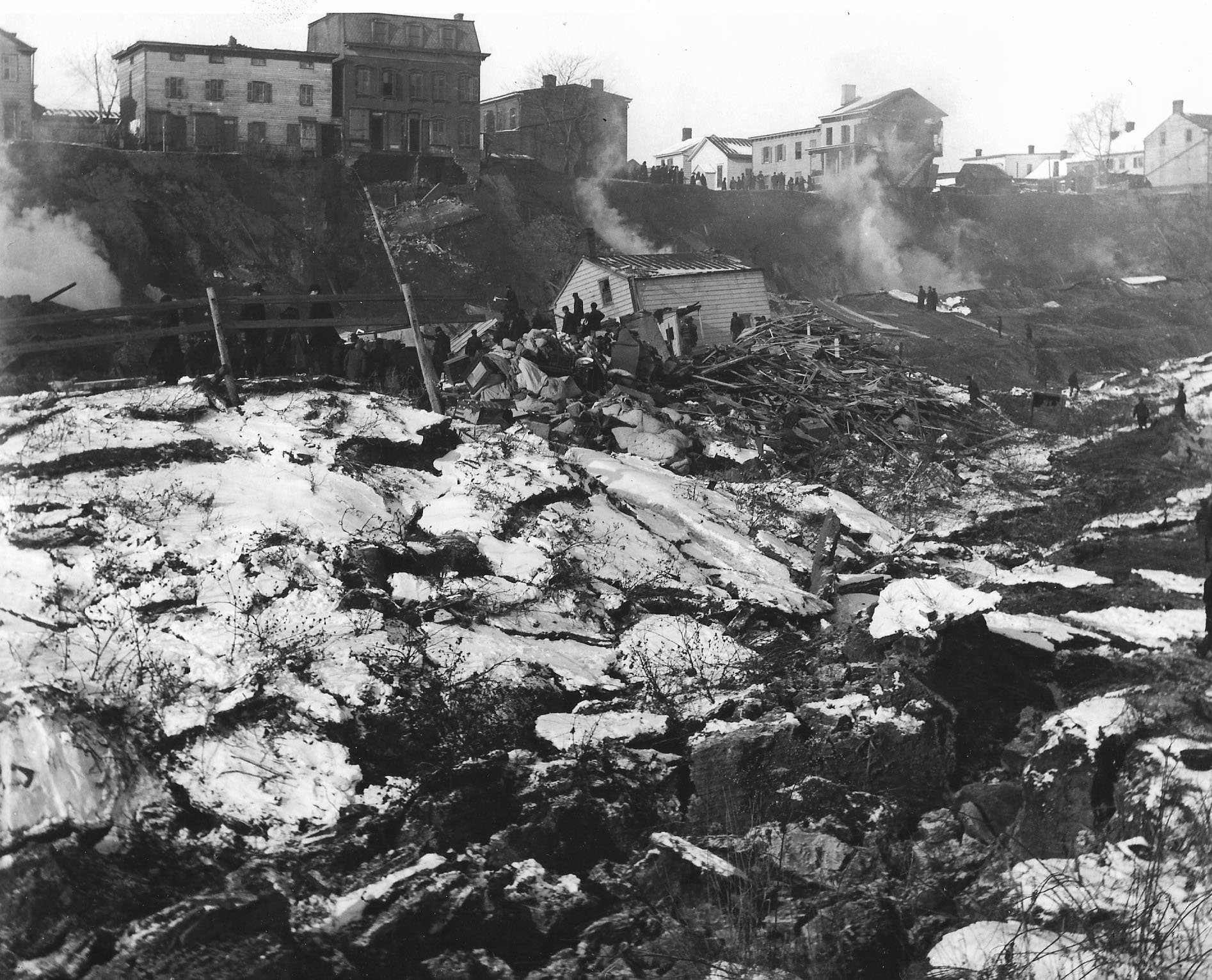
Photo of the Great Landslide of 1906, Thomas Sullivan Collection, ©Haverstraw Brick Museum Archives
On January 8, 1906, the consequences of years of excavation without thought resulted in a great landslide. Entire streets and homes were wiped off of the map, and 19 people on record were killed. Many more were possibly buried but unaccounted for.
One would think that after such a man-made catastrophe, more safeguards would be put into place to prevent rapid erosion of the shoreline. During the lawsuits against manufacturers held responsible for the landslide, the New York State Supreme Court held a special meeting in Newburgh to ask for an injunction against the defendants to stop them from mining for clay, “for fear there [would] be another landslide” in the words of the Rockland County Journal. [24]
The winter of 1908 became eerily similar to that of two years prior when on the night of February 4, a large crack ripped across in a “zigzag course from Front Street to Main Street, Allison Avenue and Liberty Street.” [25] The “most menacing” crack, according to the Rockland County Times, was the one on Main Street, running under both the Post Office and the King's Daughters’ Library
Residents were awoken by the loud noises of the “cracking of walls, the straining timbers, and the groaning caused by the settling of buildings.” In front of First Street lay the cause: “for the last three or four years, dredges have been constantly at work….extracting great volumes of clay from the bed of the Hudson River,” with the depth of digging being “not less than seventy feet.” Those “in front of the Felter /Excelsior property” dug this far to get the tightly packed clay necessary for structural bricks, with those produced at this time helping construct the East River Tunnel. [26]
Brickmakers were quick to find excuses, claiming the crack was the result of an earthquake — the epicenter of which was in Connecticut. Yet, according to the Nyack Evening Journal, “none of their neighbors felt the jar or heard the noise of the earthquake. Worry spread as the following day, February 6, a winter storm swept through the village and 7 inches of snow accumulated, hiding the crack from view. [27]
On February 8, the Haverstraw-based Rockland County Times had the story on the front page with the title “FRONT STREET DOOMED?” The final subtitle pointed complete blame against the brick manufacturers, noting that the “Repetition of Warnings” that occurred two years ago were “Now Given to Greedy [emphasis added] Malefactors.” In a similar vein, the article derided “the practices of the rich grafters, in having robbed the streets and adjacent property owners of their rights and equity,” and warned of a repetition of 1906 if the manufacturers were “not prevented by prompt and emphatic mention.” [28]

Detail Photo of Excelsior/Gillies Brickyard, circa 1907, Dan DeNoyelles Collection, ©Haverstraw Brick Museum Archives
Thankfully, front street did not collapse; however, the dangerous extraction of clay still persisted. On March 31, 1910, it was reported that excavation on the Eckerson property - one of the main culprits of the 1906 landslide - led to cracks once again forming in the land, this time slightly north of Jefferson Street. Both the Village Board of Trustees and Council met to discuss the issue; however, the Nyack Evening Journal reported only that they had deemed “danger exists” and, with this, notified nearby residents. [29] By 1913, Eckerson fled the state to avoid legal suits against him for his role in the 1906 slide. [30]
By 1911, small brickyards used 50-80 tons a clay, with the largest using 500 tons and even greater. On September 16, 1911, roughly 75 Hudson River Manufacturers joined together at the Palatine Hotel in Newburgh, in a meeting chaired by Senator John B. Rose, and co-chaired by Secretary Hiram Merritt of Ulster, to discuss the “Conservation of Clay.” Although it was not an official meeting of the Greater Brick Company of New York, which held their meetings in NYC, the manufacturers discussed similar plans to “conserve” clay “by governing shipments so that they will conform to the actual market conditions.” [31]
Conservation of clay did not seem to be followed as, within the next two decades, Haverstraw manufacturers were running out of the raw material. In 1929, the Fowler yard employed a dredge off of Front Street “in the flats,” with a plan for the “future source supply” being “the bottom of the river.” [32]
However, by the end of the season, there was a great deal of uncertainty as to the longevity of Haverstraw brick making, as it was reported that the Excelsior Brick Company was running out of clay. While they had continued to dig into the side of the hill on their property, they had by now stopped in fear of another great landslide. They thus “had to dredge the river for clay.” However, due to market conditions, dredging was becoming a much costlier endeavor, pushing the company to close their yards early despite building winter-resistant architecture on their yard.
Although many were now without employment, a great deal of residents of the village looked upon the closing of yards as positive. To them, it meant that “at last Haverstraw will no longer be undermined and dug up to the point where every beauty spot has been removed.” [33]
death and rebirth

Photo of Glass Eels Courtesy of Lamont-Doherty Earth Observatory.
The subsequent decade marked the death knell of the Haverstraw industry, with the Rockland Brick Company on the former De Noyelles’ property being the last standing manufacturer in the village. [34] In what was seemingly a last gasp of air, the company employed a new dredging method that was reported by the Times on the front page with an expectation to “effect a real economy” in replacing the then-current “cumbersome process.”
The new process consisted of a dredge lowering a long steel pipe into the river bed, equipped with a pointed spinning tip at its end to dig into the clay deposits. From here, the clay was pumped through the dredge and into a floating pipeline that deposited a mixture of ¾ water and ¼ clay onto the brickyard, the former washing back into the river. It was expected that this process would exploit 9000 cubic yards of clay every 24 hours. [35]
Ultimately, the new method of dredging was a dud. In November of 1942, the Company went out of business with a whimper, with the Times reporting the company officially filing with the New York Department of State for dissolution on page 7, marking the complete end of Haverstraw brickmaking. [36]
The Haverstraw brick industry, Yet inevitably died due to over extraction. However, despite the untold damage that it did to the river and its banks, a new future is being born. Many of the clay pits excavated for brickyard production have now been filled in by the Hudson, creating numerous spawning grounds for fish and wildlife. Each spring, glass eel populations are repairing themselves, migrating from the Saragossa Sea between Bermuda and Puerto Rico, and into the estuary that is the Minnisceongo Creek. Here, and now without brickyard interference, they grow to yellow and then silver eels, completing their growth cycle needed to swim back to the Saragossa Sea to lay eggs and die.
Written by Luke Spaltro, Museum Historian. Edited by Rachel Whitlow, Executive Director.
Works cited and further reading
[1] Frederick J. H. Merrill and Heinrich Reis, “Clay Industries of New York,” Bulletin of the New York State Museum, Vol. 3, No. 12 (Albany: University of the State of New York, Mar. 1895),104-105, 109, 114.https://archive.org/details/annualreportofre4818newy/page/n675/mode/1up?q=haverstraw
[2] “THE BRICK INDUSTRY,” Rockland County Times, Vol. XIV, No. 4, Oct. 11, 1902, 5. https://news.hrvh.org/veridian/?a=d&d=rocklandctytimes19021011.2.21&srpos=32&e=-------en-20--21-byDA-txt-txIN-%22dredge%22+brick------
[3] “THE BRICK INDUSTRY,” Rockland County Times, Vol. XIV, No. 4, Oct. 11, 1902, 5. https://news.hrvh.org/veridian/?a=d&d=rocklandctytimes19021011.2.21&srpos=32&e=-------en-20--21-byDA-txt-txIN-%22dredge%22+brick------ ; Merrill and Reis, “Clay Industries of New York,” 145.
[4] Merrill and Reis, “Clay Industries of New York,” 145-7, 179-180; Daniel deNoyelles, Within These Gates (Thiells: Haverstraw Brick Museum, 2002), 49.
[5] “WILL DREDGE CLAY FOR BRICK IN NEW WAY,” Rockland County Times, Vol. XLVIII, No. 14, Mar. 2, 1940, 1. https://news.hrvh.org/veridian/?a=d&d=rocklandctytimes19400302.1.1&srpos=60&e=-------en-20--41-byDA-txt-txIN-%22dredge%22+clay------
[6] Merrill and Reis, “Clay Industries of New York,” 147.
[7] Chas R. Swain to George M. Lilburn, Mar. 24, 1894, Lilburn Family Papers Collection.
[8] John P. Randerson to the Lilburn Properties, Mar. 15, 1894, Lilburn Family Papers Collection.
[9] H. H. Petze to James W. Gillies, Mar. 20, 1897, Lilburn Family Papers Collection.
[10] H. A. Marvel to George M. Lilburn, Mar. 27, 1897, Lilburn Family Papers Collection.
[11] H. A. Marvel to George M. Lilburn, Oct. 28, 1897, Lilburn Family Papers Collection.
[12] H. A. Marvel to George M. Lilburn, Jan. 4, 1898, Lilburn Family Papers Collection.
[13] E. M. Payne & Co. to George M. Lilburn, Apr. 14, 1897, Lilburn Family Papers Collection.
[14] E. M. Payne & Co. to George M. Lilburn, Mar. 15, 1897, Lilburn Family Papers Collection.
[15] E. M. Payne & Co. to George M. Lilburn, Apr. 16,1897, Lilburn Family Papers Collection.
[16] ? to George M. Lilburn, Dec. 19, 1901, Lilburn Family Papers Collection.
[17] “STREET IS CRACKED,” Rockland County Times, Vol. XIII, No. 39, Jun. 14, 1902, 1. https://news.hrvh.org/veridian/?a=d&d=rocklandctytimes19020614.2.6&srpos=1&e=------190-en-20-rocklandctytimes-1-byDA-txt-txIN-%22crack%22+rockland+----1902--
[18] “A Landslide,” Nyack Evening Star, Vol. 5, No. 272, May 18, 1898, 1. https://news.hrvh.org/veridian/?a=d&d=jbaggcgi18980518-01.1.1&srpos=33&e=-------en-20--21--txt-txIN-%22landslide%22+clay+haverstraw------
[19] ? to The Lilburn Estate, May 19, 1899, Lilburn Family Papers Collection.
[20] “Grassy Point,” Rockland County Times, Vol. XIII, No. 11, Nov. 30, 1901, 8. https://news.hrvh.org/veridian/?a=d&d=rocklandctytimes19011130.2.83&srpos=36&e=------190-en-20--21-byDA-txt-txIN-dredge------
[21] “Certificate Filed,” Rockland County Times, Vol. XIII, No. 37, May 31, 1902, 1. https://news.hrvh.org/veridian/?a=d&d=rocklandctytimes19020531.2.6.3&srpos=26&e=-------en-20--21-byDA-txt-txIN-%22dredge%22+clay------
[22] “STREET IS CRACKED,” 1.
[23] “THE BRICK INDUSTRY,” 5.
[24] “Fear Another Landslide,” Rockland County Journal, Aug. 10, 1907, 1. https://news.hrvh.org/veridian/?a=d&d=rocklandctyjournal19070810.1.1&srpos=48&e=-------en-20--41--txt-txIN-%22landslide%22+clay+haverstraw------
[25] “Say ‘Quake Caused It,” Nyack Evening Journal, Feb. 6, 1908, 1. https://news.hrvh.org/veridian/?a=d&d=jaaggbbf19080206-01.1.1&srpos=64&e=------190-en-20--61-byDA-txt-txIN-haverstraw+landslide------
[26] “FRONT STREET DOOMED?” Rockland County Times, Vol. XIX, No. 17, Feb. 8, 1908, 1.
[27] “Say ‘Quake Caused It,” 1.
[28] “FRONT STREET DOOMED?” 1.
[29] “A Landslide Threatened,” Nyack Evening Journal, Mar. 31, 1910, 1.
[30] “ECKERSON IS STILL A FUGITIVE,” Rockland County Journal, Jan. 11, 1913, https://news.hrvh.org/veridian/?a=d&d=rocklandctyjournal19130111.1.1&srpos=19&e=-------en-20--1--txt-txIN-%22landslide%22+clay+haverstraw------
[31] “STOP RECKLESS WASTE OF CLAY,” Rockland County Times, Vol. XXII, No. 47, Sep. 16, 1911, 1. https://news.hrvh.org/veridian/?a=d&d=rocklandctytimes19110916.1.1&srpos=36&e=-------en-20--21-byDA-txt-txIN-%22dredge%22+clay------
[32] “NEW SYSTEM WORKING,” Rockland County Times, Vol. XXXIX, No. 27, Aug. 31, 1929, 1-3. https://news.hrvh.org/veridian/?a=d&d=rocklandctytimes19290831.1.3&srpos=12&e=------192-en-20-rocklandctytimes-1-byDA-txt-txIN-dredge------
[33] “Haverstraw Brickyards Give Up Long Fight, Close Down Plants,” Rockland County Journal, Vol. 42, No. 172, Nov. 16, 1929, 1-2. https://news.hrvh.org/veridian/?a=d&d=jbaghabf19291116.1.1&srpos=47&e=-------en-20--41-byDA-txt-txIN-%22dredge%22+clay------
[34] . Wilson Bartine, “Lone Brickyard Remains of Many That Once Lined Shore,” The Journal News, Vol. 51, No. 190, Dec. 17, 1940, 10. https://news.hrvh.org/veridian/?a=d&d=ieadbehj19401217.1.10&srpos=7&e=------194-en-20--1-byDA-txt-txIN-%22Rockland+brick+company%22------
[35] “WILL DREDGE CLAY FOR BRICK IN NEW WAY,” Rockland County Times, Vol. XLVIII, No. 14, 1. https://news.hrvh.org/veridian/?a=d&d=rocklandctytimes19400302.1.1&srpos=12&e=------194-en-20--1--txt-txIN-dredge+------
[36] Rockland County Times, Vol. L, No. 51, Nov. 14, 1942, 7. https://news.hrvh.org/veridian/?a=d&d=rocklandctytimes19421114-01.1.7&srpos=20&e=------194-en-20--1-byDA-txt-txIN-%22Rockland+brick+company%22------